Space-Track.org: The Essential Guide for Navigating Cosmos
Introduction: When the Universe Calls Back
Remember that kid from Disney’s Elio who got accidentally beamed up to the Communiverse? Well, unlike Elio’s fictional interplanetary mishap, real-world space systems engineers need precise, reliable data to track what’s actually happening up there. That’s where Space-Track.org comes in your mission-critical portal to space situational awareness.
You know what’s fascinating? While Elio found himself thrust into an alien diplomatic crisis without preparation, we space professionals have the luxury of comprehensive tracking data. However, navigating Space-Track.org can feel almost as overwhelming as trying to represent Earth to a cosmic confederation.
Space-Track.org isn’t just another website; it’s the authoritative source for satellite tracking data maintained by USSPACECOM. Whether you’re designing constellation architectures, planning mission trajectories, or analyzing orbital debris risks, this platform provides the foundational data that keeps our space operations safe and successful.

What is Space-Track.org and Who’s Behind the Magic?
Space-Track.org serves as the official public gateway to the United States Space Surveillance Network’s data, operated by USSPACECOM through the 18th Space Control Squadron. Think of it as the ultimate space traffic control center, except instead of managing airport runways, we’re tracking thousands of objects whizzing around Earth at 17,500 mph.
See their homepage here – https://www.petersonschriever.spaceforce.mil/About-Us/Fact-Sheets/Display/Article/3016228/18th-space-defense-squadron/
The platform emerged from a critical need: as space became increasingly crowded, engineers required accurate, up-to-date information about orbital objects. Imagine trying to design a satellite mission without knowing where other spacecraft are, it’s like planning a road trip blindfolded while someone else drives. Not exactly confidence-inspiring, right?
Here’s what makes Space-Track.org special:
- Authoritative Data Source: Direct from the U.S. military’s space surveillance network
- Comprehensive Coverage: Tracking objects as small as 10 centimeters
- Real-Time Updates: Fresh data multiple times daily
- Free Access: No cost for basic tracking information
- API Integration: Programmatic access for automated systems
The Space Surveillance Network Behind the Curtain
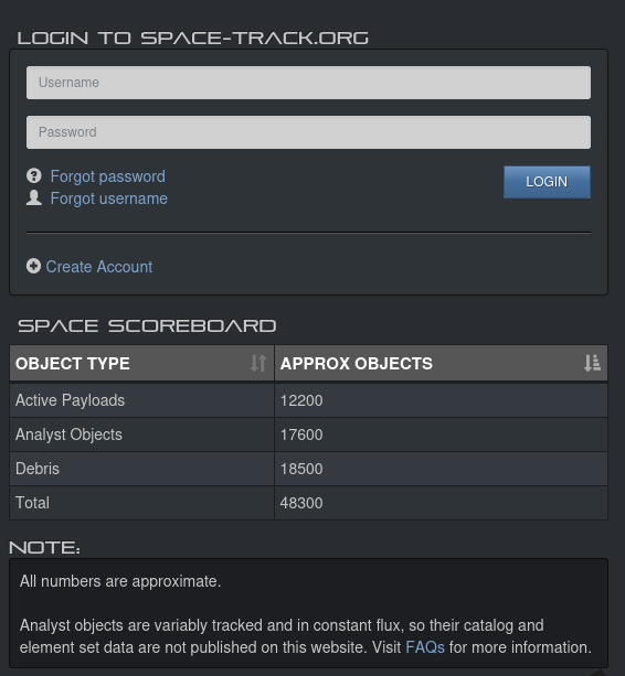
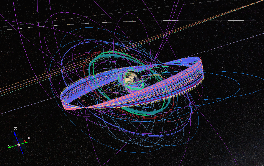
The data flowing through Space-Track.org comes from a sophisticated network of ground-based radars and optical sensors. This isn’t some casual stargazing setup, we’re talking about military-grade tracking systems that can detect a softball-sized object in orbit. As of recent counts, the catalog tracks over 58,000 objects, including more than 16,000 satellites launched since 1957.
Just like how Elio had to learn about the vast Communiverse quickly, new users often feel overwhelmed by the sheer scale of what’s being monitored. But once you understand the system’s structure, it becomes an incredibly powerful tool for space systems engineering.
Getting Started: Your Space-Track.org Account Setup
Is Space-Track.org free to use? Absolutely! Basic access is completely free, though you’ll need to register for an account. Think of it as getting your passport to the final frontier, except this one doesn’t require awkward photos or long lines at government offices.
Creating Your Account: A Step-by-Step Journey
The registration process is straightforward, but there are some nuances worth understanding:
- Visit the Registration Page: Navigate to space-track.org and click “Register”
- Provide Basic Information: Standard contact details and intended use
- Wait for Approval: Most accounts are approved within 24 hours
- Verify Your Email: Check your inbox and confirm your account
Pro Tip: When describing your intended use, be specific about your professional role. Mentioning “space systems engineering” or “orbital analysis” helps expedite approval. The administrators appreciate knowing they’re providing data to qualified professionals rather than casual curiosity seekers.
Understanding Access Levels and Permissions
Space-Track.org operates on tiered access levels. Basic users get access to most Two-Line Element Sets (TLEs) and general Satellite Catalog (SATCAT) information. However, some sensitive data requires additional permissions think of it as security clearance levels, but for space geeks.
Here’s what basic users can access:
- Current and historical TLE data
- Satellite decay predictions
- Basic orbital elements
- General catalog information
- Conjunction screening results
What data is available to basic users? The standard account provides everything most engineers need for mission planning, orbital analysis, and situational awareness. Unless you’re working on classified projects or need specialized military-grade data, the basic tier covers your requirements completely.
| Access Level | TLE Data | SATCAT Access | Reentry Predictions | CDM Data | API Access |
|---|---|---|---|---|---|
| Basic | ✓ | ✓ | ✓ | Limited | ✓ |
| Enhanced | ✓ | ✓ | ✓ | ✓ | ✓ |
| Special | ✓ | ✓ | ✓ | ✓ | Advanced |
Understanding Two-Line Element Sets: The DNA of Orbital Mechanics
What are Two-Line Element Sets (TLEs) and how do I use them? TLEs are the fundamental building blocks of satellite tracking, essentially the genetic code that describes an object’s orbit. If you’ve ever worked with orbital mechanics, you know that describing a satellite’s position and velocity requires six parameters. TLEs package these parameters (plus additional information) into a standardized, compact format.
Decoding the TLE Format
A typical TLE looks like gibberish to the uninitiated:
NOAA 181 28654U 05018A 23001.12345678 .00000123 00000-0 12345-3 0 99912 28654 99.1234 123.4567 0012345 45.6789 314.1592 14.12345678123456
But to us engineers, this is pure gold. Let me break down what each component tells us:
Line 1 Breakdown:
- Catalog Number: Unique identifier (28654)
- Classification: U for unclassified
- International Designator: Launch year and sequence (05018A)
- Mean Motion Derivatives: Orbital decay parameters
- Element Set Number: Version tracking
Line 2 Breakdown:
- Inclination: Orbital plane angle (99.1234°)
- Right Ascension: Orbital plane orientation (123.4567°)
- Eccentricity: Orbital shape (0.0012345)
- Argument of Perigee: Orbit orientation (45.6789°)
- Mean Anomaly: Satellite position (314.1592°)
- Mean Motion: Orbital period (14.12345678 revolutions/day)
Practical TLE Applications in Systems Engineering
TLEs aren’t just academic curiosities, they’re essential tools for practical space systems work. Here’s how I use them regularly:
Mission Planning: Before designing any space mission, I download TLEs for existing objects in target orbits. This helps identify potential interference, collision risks, and frequency coordination issues.
Conjunction Analysis: TLEs feed directly into conjunction assessment tools. When two objects’ orbits might intersect, TLE data provides the foundation for collision probability calculations.
Ground Station Scheduling: Pass prediction software uses TLEs to calculate when satellites will be visible from specific ground locations. Without accurate TLE data, you’re essentially guessing when your expensive ground stations can communicate with spacecraft.
The Satellite Catalog (SATCAT): Your Comprehensive Space Database
What is the Satellite Catalog (SATCAT)? Think of SATCAT as the ultimate registry of everything we’ve launched into space, like a cosmic DMV database, but infinitely more useful and less bureaucratic. The catalog maintains records of over 58,000 objects, tracking everything from active satellites to spent rocket stages and debris fragments.
SATCAT Data Structure and Content
Each SATCAT entry contains crucial metadata that TLEs alone can’t provide:
- Object Name: Common identifier (e.g., “HUBBLE SPACE TELESCOPE”)
- NORAD Catalog Number: Unique tracking ID
- International Designator: Launch-based classification
- Object Type: Payload, rocket body, or debris
- Operational Status: Active, inactive, or decayed
- Launch Information: Date, site, and vehicle details
- Physical Characteristics: Size, mass, and shape (when available)
- Orbit Classification: LEO, MEO, GEO, or highly elliptical
This information proves invaluable when you’re trying to understand the context behind orbital data. For instance, knowing whether an object is an active satellite or dead rocket stage completely changes how you approach conjunction analysis or frequency coordination.
Practical Applications for Space Systems Engineers
Debris Assessment: When designing new missions, SATCAT helps identify debris concentrations in target orbital regions. I often query the database to understand how cluttered specific orbital shells have become, crucial information for mission risk assessment.
Heritage Analysis: Looking at similar satellites in the catalog provides insights into operational lifespans, common failure modes, and orbital evolution patterns. It’s like having a historical database of space missions at your fingertips.
Regulatory Compliance: Many space agencies require detailed knowledge of existing orbital populations before approving new missions. SATCAT provides the authoritative data needed for these regulatory submissions.
Mastering Conjunction Data Messages (CDMs): Collision Avoidance in Practice
What is a Conjunction Data Message (CDM)? CDMs represent one of Space-Track.org’s most critical safety features, automated alerts when two objects might collide in orbit. The CDM provides spaceflight safety information in a single standardized product, replacing the previous dual-product system.
Just as Elio had to navigate complex diplomatic situations in the Communiverse, satellite operators must constantly manage collision risks in Earth’s orbital environment. CDMs are essentially the diplomatic communications that help prevent cosmic catastrophes.
Understanding CDM Structure and Content
A typical CDM contains:
Object Identification:
- Primary and secondary object catalog numbers
- Object names and international designators
- Operational status and contact information
Encounter Geometry:
- Time of closest approach (TCA)
- Miss distance at TCA
- Relative velocity between objects
- Probability of collision (Pc)
Uncertainty Information:
- Position and velocity error covariances
- Hard body radii for collision modeling
- Confidence levels and data quality indicators
CDM Processing and Response Procedures
When you receive a CDM, your response depends on several factors:
Collision Probability Assessment: Generally, probabilities above 1:10,000 warrant serious attention. However, the threshold varies based on mission criticality and maneuver capabilities.
Maneuver Planning: If avoidance is necessary, CDM data feeds directly into trajectory optimization tools. The goal is minimal fuel expenditure while achieving adequate risk reduction.
Coordination Requirements: High-value assets often require coordination between multiple operators. CDMs provide the standardized data format needed for these discussions.
Insert image of CDM workflow diagram here
Reentry Predictions: When Satellites Come Home
How do I access satellite decay and reentry predictions? Space-Track.org provides comprehensive reentry prediction services, tracking objects as they spiral toward Earth’s atmosphere. This isn’t just academic interest, uncontrolled reentries can pose risks to populated areas and aviation.
The Physics of Satellite Decay
Understanding reentry predictions requires grasping the underlying physics. Atmospheric drag gradually lowers satellite orbits, with the decay rate depending on:
- Atmospheric Density: Varies with solar activity and altitude
- Object Characteristics: Surface area, mass, and shape
- Orbital Parameters: Altitude, inclination, and eccentricity
- Space Weather: Solar storms increase atmospheric expansion
How are reentry predictions generated and confirmed? The process combines precise orbital tracking with atmospheric modeling. However, predictions become increasingly uncertain for timeframes beyond a few days, similar to weather forecasting, but with objects moving at orbital velocities.
Practical Applications and Limitations
Mission End-of-Life Planning: When designing satellites, engineers must consider disposal requirements. Reentry predictions help determine whether natural decay meets regulatory timelines or if active deorbit is required.
Risk Assessment: Large objects pose potential ground hazards during reentry. Prediction accuracy becomes crucial for population safety and aviation routing.
Debris Environment Modeling: Understanding how objects naturally clear from orbit helps model long-term debris population evolution.
Important Caveat: Reentry timing predictions carry significant uncertainty, especially beyond 48-72 hours. Plan accordingly and don’t rely on precise timing for critical operations.
Space-Track API: Automating Your Workflow
Modern space systems engineering demands automated data processing. Manually downloading TLEs or checking conjunction reports simply doesn’t scale for operational systems. That’s where Space-Track API access becomes essential.
API Fundamentals and Authentication
The Space-Track.org API uses RESTful architecture with standard HTTP methods. Authentication requires your account credentials, and sessions expire after inactivity. Here’s the basic workflow:
- Authenticate: POST credentials to obtain session cookie
- Query Data: GET requests with appropriate parameters
- Process Results: JSON or CSV formatted responses
- Maintain Session: Keep alive or re-authenticate as needed
Common API Use Cases
Automated TLE Updates: Mission control systems often download fresh TLEs hourly or daily. The API enables this automation without human intervention.
Conjunction Monitoring: Automated CDM processing allows real-time collision risk assessment. Critical for operational spacecraft with autonomous navigation systems.
Database Synchronization: Many organizations maintain internal orbital databases synchronized with Space-Track.org data. The API facilitates these regular updates.
Research Applications: Academic institutions use the API for large-scale orbital mechanics studies, requiring massive historical datasets.
# Example API authentication workflowimportrequests# Authenticate and establish sessionauth_url="https://www.space-track.org/ajaxauth/login"credentials={"identity":"username","password":"password"}session=requests.Session()session.post(auth_url, data=credentials)# Query TLE datatle_url="https://www.space-track.org/basicspacedata/query/class/tle_latest"response=session.get(tle_url+"/NORAD_CAT_ID/25544/format/json")iss_tle=response.json()
Advanced Features and Specialized Services
Satellite Owner/Operator Registration
How can satellite operators register their spacecraft? Space-Track.org provides registration services for new satellites, ensuring accurate catalog information from launch. This process involves:
- Pre-launch coordination with tracking authorities
- Providing orbital parameters and contact information
- Establishing communication protocols for conjunction warnings
- Maintaining updated operational status information
Data Sharing Agreements and Redistribution
How do I request permission to redistribute Space-Track data? The platform operates under specific terms of use regarding data redistribution. While individual use is generally unrestricted, commercial redistribution or large-scale sharing requires formal agreements.
Specialized Research Access
Academic institutions and research organizations can request enhanced access for legitimate research purposes. This often includes:
- Historical data archives
- Specialized analysis tools
- Enhanced API limits
- Collaboration with USSPACECOM analysts
Space-Track vs. Alternative Platforms: Making the Right Choice
What is the difference between Space-Track and other tracking sites like CelesTrak? This question comes up frequently, and the answer depends on your specific requirements.
Space-Track.org Advantages
- Authoritative Source: Direct from USSPACECOM
- Comprehensive Data: Full catalog access
- Official Status: Government-backed reliability
- Specialized Services: CDMs, reentry predictions, registration
CelesTrak and Other Alternatives
- Simplified Interface: Often more user-friendly
- Specialized Formats: Tailored for specific applications
- Amateur Radio Focus: Enhanced support for ham radio operators
- Educational Resources: Better learning materials
Choosing the Right Platform
For professional space systems engineering, Space-Track.org remains the gold standard. However, alternative platforms excel in specific niches:
Academic Teaching: CelesTrak’s educational resources and simplified interface work better for classroom environments.
Amateur Radio: Specialized sites provide better support for ham radio satellite operations.
Quick Analysis: Some platforms offer superior visualization tools for rapid orbital analysis.
Mobile Applications: Third-party apps often provide better mobile experiences than Space-Track.org’s web interface.
| Platform | Data Source | Interface | Mobile | Educational | API |
|---|---|---|---|---|---|
| Space-Track.org | Authoritative | Complex | Limited | Basic | Full |
| CelesTrak | Space-Track | Simplified | Good | Excellent | Limited |
| N2YO | Space-Track | Visual | Excellent | Good | Basic |
| SatView | Space-Track | Modern | Good | Fair | None |
Troubleshooting and Support Resources
Common Issues and Solutions
Login Problems: Account approval can take 24-48 hours. Ensure you’ve verified your email address and provided complete registration information.
Data Quality Questions: TLE accuracy degrades over time. Always use the most recent elements available, especially for precision applications.
API Rate Limits: The system implements usage throttling to prevent abuse. Implement appropriate delays in automated scripts.
Format Confusion: Different data formats serve different purposes. Understand whether you need TLEs, vectors, or specialized formats for your application.
Getting Help When You Need It
How do I contact Space-Track.org for support? The platform provides several support channels:
- Online documentation and FAQs
- Email support for technical issues
- User forums for community assistance
- Direct contact for specialized requirements
Support Response Times: General inquiries typically receive responses within 2-3 business days. Technical API issues often get faster attention, while account-related questions may take longer.
Building Internal Expertise
Don’t rely solely on external support. Building internal Space-Track.org expertise pays dividends:
Document Your Workflows: Create internal procedures for common tasks like TLE downloads and conjunction analysis.
Train Multiple Staff Members: Avoid single points of failure in critical operations.
Maintain Test Accounts: Use separate accounts for development and operational systems.
Stay Current: Space-Track.org regularly updates features and data formats. Subscribe to announcements and test changes before they affect operations.
Advanced Applications: Real-World Engineering Scenarios
Constellation Design and Management
Modern satellite constellations require sophisticated tracking and coordination. Space-Track.org data feeds directly into constellation management systems, enabling:
Orbital Slot Coordination: Ensuring new satellites don’t interfere with existing operations requires detailed knowledge of occupied orbital regions.
Formation Flying: Precision constellation geometries demand accurate relative positioning, which depends on high-quality TLE data.
Collision Avoidance: Large constellations create complex conjunction scenarios requiring automated processing of multiple CDMs simultaneously.
Mission Planning Integration
Launch Window Analysis: TLE data helps identify potential conflicts during launch ascent trajectories. You don’t want your new satellite colliding with existing objects during insertion maneuvers.
Ground Station Optimization: Pass prediction accuracy directly impacts ground station utilization efficiency. Better TLE data means more precise scheduling and higher data throughput.
Lifetime Analysis: Historical tracking data reveals how similar satellites have evolved orbitally over time, informing mission duration estimates and fuel budgeting.
Regulatory Compliance and Documentation
Space agencies worldwide increasingly require detailed orbital analyses for mission approval. Space-Track.org provides the authoritative data needed for:
- FCC frequency coordination filings
- ITU satellite network notifications
- National space agency licensing applications
- International debris mitigation compliance
The Future of Space Situational Awareness
As space becomes increasingly congested, platforms like Space-Track.org must evolve to meet growing demands. Several trends are shaping the future:
Enhanced Tracking Capabilities: New sensor networks will enable tracking of smaller objects, improving collision prediction accuracy.
Commercial Integration: Growing partnerships with commercial tracking providers will supplement government capabilities while maintaining data quality standards.
Automated Decision Making: AI-powered systems will increasingly use Space-Track.org data for autonomous spacecraft operations, requiring enhanced API capabilities and data reliability.
International Cooperation: Expanding data sharing agreements with allied nations will provide more comprehensive global coverage.
Conclusion: Your Gateway to the Final Frontier
Just as Elio discovered that the universe is far more complex and interconnected than he initially imagined, space systems engineers must navigate an increasingly sophisticated orbital environment. Space-Track.org serves as our essential compass in this cosmic wilderness, providing the accurate, timely data needed for safe and successful space operations.
Throughout my decade of experience in space systems engineering, I’ve watched Space-Track.org evolve from a basic tracking service into a comprehensive space situational awareness platform. The lessons learned from supporting Department of Defense missions have taught me that success in space depends on understanding not just your own systems, but the entire environment in which they operate.
Whether you’re designing the next generation of Earth observation satellites, planning interplanetary missions, or managing operational spacecraft, Space-Track.org provides the foundational data that makes it all possible. Like Elio learning to navigate the Communiverse’s complex diplomatic landscape, mastering Space-Track.org requires patience, practice, and appreciation for the intricate dance of objects in Earth’s orbital environment.
The platform’s combination of authoritative data, comprehensive coverage, and professional-grade tools makes it indispensable for serious space systems work. While the interface may seem daunting initially, much like Elio’s first encounter with alien technology, the investment in learning these systems pays enormous dividends in operational capability and mission success.
Remember that space situational awareness isn’t just about knowing where things are right now; it’s about understanding how the orbital environment evolves over time and how your missions fit into that larger picture. Space-Track.org provides both the current snapshot and the historical context needed for informed engineering decisions.
As we continue pushing the boundaries of space exploration and commercialization, platforms like Space-Track.org become even more critical. The data flowing through these systems enables everything from collision avoidance to mission planning, from regulatory compliance to scientific research.
Ready to dive deeper into space situational awareness? Start by creating your Space-Track.org account today and exploring the vast wealth of orbital data at your fingertips. Practice with TLE downloads, experiment with the API, and gradually build the expertise that will serve you throughout your space systems engineering career.
After all, unlike Elio’s accidental cosmic adventure, your space engineering career can benefit from all the preparation and accurate data you can get. The universe may be calling, but with Space-Track.org, you’ll be ready to answer with confidence and precision.
What aspects of Space-Track.org do you find most challenging? Share your experiences and questions in the comments below, and let’s build a community of space systems engineers helping each other navigate the final frontier.